Malaysian Airlines Flight MH17 on July 17, 2014, was a potential game changer for global geopolitics and the New Cold War. However, a funny thing happened on the way to the Kremlin…
In this report, we will lay out the facts based on a wide breadth of available information and data surrounding MH17. We will also present and give critique to Washington and Kiev’s “mountain of evidence” that has saturated US and European-based media coverage since the incident took place.
21WIRE has compiled this report with the help of many contributors and references from English-speaking media, as well as material translated from Russian and Ukrainian media sources, along with other historical references to provide context. Our objective is to get as close to the truth as possible. Although revelations will appear to be self-evident, we still encourage the public to draw their own conclusions regarding this pivotal event.
LISTEN TO 21WIRE’S FULL MH17 AUDIO REPORT HERE
There are other well-known anomalies surrounding this event which have been covered at 21WIRE, as well as connections to MH370, but for the purposes of this investigation we will focus on both factual and speculative evidence brought forth by the US, Ukraine and Russia.
As we will clearly demonstrate, the only wild conspiracy theories being pushed right now, are those coming out of the US State Department, and the government in Kiev, Ukraine, which are being repeated by CNN, BBC, FOX-NewsCorp, ABC, CBS and NBC…
The Brink of War
Last Monday morning was not a pleasant one for the US State Department. Russian officials surprised Washington and its NATO partners when it released all available satellite imagery and air traffic control data which was recorded in and around the final minutes of Flight MH17 – and presented it to the world media on live television. The data painted a very different picture, drawing contrasting conclusions to what Washington and Kiev officials had been disseminating via western media since July 17th. Following their presentation, Moscow handed its findings – air traffic data and time stamped satellite imagery – to European authorities. We will review those findings in detail later in this report. In stark contrast, US officials have been reluctant to do the same. Is Washington willing to share any object data or evidence to the public, or is it only interested in sharing that which somehow fits into the same predetermined narrative it stood by on July 17th, one which already assigned guilt to both rebel fighters in eastern Ukraine and Russia?
We hope that political leaders and media organizations in the US and Europe will take the time to consider all available information, rather than simply repeat and spin what is bouncing around the media echo chamber. It’s also crucial to understand the geopolitical context in which this incident has occurred in order to discover who really possessed the motive, and the means to destroy this passenger aircraft, and which parties stand to benefit most from such an international incident.
After reviewing the evidence, all indicators points to the downing of MH17 as a highly coordinated, but failed false flag event.
MH17: A Doomed Flight Path
A Malaysian Airlines spokesman has already confirmed that, for some unknown reason, Kiev-based Ukrainian Air Traffic Control (ATC) ordered MH17 off of its original flight path along the international air route, known as L980.
Most likely, this order was given to pilots while MH17 was still in Polish air space. L980 is one of the most popular and most congested air routes in the world, as well as a key link between major international hubs in Europe, like London Heathrow, Amsterdam Schiphol, and Frankfurt, and Asian destinations, like Singapore, Mumbai, Hong Kong and Kuala Lumpur.
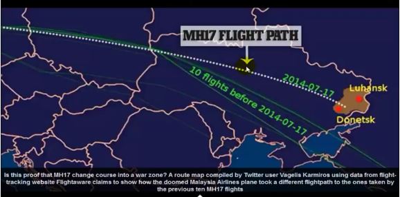
As MH17 moved into Ukrainian air space, it was moved by ATC Kiev approximately 200 miles north – putting it on a new course, heading directly into a war zone, a well-known dangerous area by now – one that’s hosted a number of downed military craft over the previous 3 weeks.
Robert Mark, a commercial pilot and editor of Aviation International News Safety magazine, confirmed that most Malaysia Airlines flights from Amsterdam to Kuala Lumpur would normally travel along a route significantly further south than the route MH17 was diverted onto. Data on all airline flight records can be found here.

UPDATE TBC: A number of bloggers have reported that the past flights on FlightRadar andFlightAware were changed between July 24-25th, the new “old flights” were placed over the Donetsk People’s Republic instead of the flights going further south. This does not jibe with what was reported last week by researcher Vagelis Karmiros using data from flight-tracking website Flightaware and published on a number established sites like Zero Hedge. Stay tuned here for updates.
The Event
The fatal event occurred somewhere in the interval between 17:21:28 and 17:22:30 Moscow Time. The exact time of the crash is believed to be at 5:23pm. The last available geographic coordinates can be found here on Flight Radar24:
Weather and Visibility Factor
Kiev-based air traffic controllers not only led MH17 right over its alleged ‘target zone’ in Eastern Ukraine’s Donetsk region, but also helped make it visible.
Although weather data online is all but unavailable for the area of Donetsk, Ukraine for July 17th, conditions are evident by numerous videos depicting the crash and crash site in the aftermath – it was cloudy and overcast, with more visibility above the cloud canopy. This factor is important because at its cruising altitude of approximately 33,000 feet (10,000 meters), the airliner would not be visible from the ground in the rebel-held area where Washington is insisting a SAM missile was launched. Why Kiev air traffic controllers order MH17 to suddenly drop its altitude, from 35,000 feet to around 33,000 feet, just before the plane’s demise is unknown for sure, but it would have been near impossible for the alleged rebel gunman occupying this relatively small rebel-held patch of land to make a visual sighting of MH17 and acquire the target during the 1-2 minute window they would have had (assuming they were even in possession of the BUK missile system).
The Los Angeles Times reports:
The probability that this is all an ‘unfortunate coincidence’ reduces to near zero when one considers the air traffic data and Kiev’s denial of the close proximity of its Ukrainian SU-25 fighter jet in pursuit of MH17 minutes before the crash (see ‘Aircraft in the Vicinity’ below).
Small Rebel Target Window
Much has been made by the US and its media of MH17 being shot down and crashing in “the rebel-held area”, but few are aware of just how small the said area actually is. The Ukrainian military had already isolated the rebel area which Kiev and Washington insist a rebel-controlled BUK SAM missile battery had fired on the passenger jet. The actual size of this rebel-held patch is only 50 miles wide, with MH17 approaching on a southeastern route over Horlivka, the frontline of this rebel-held zone, towards Snezhnoye (Snizhne). Cruising at 580 mph (933 kmph), MH17 would have only been visible for a very short time – just over 1 minute (if Kiev had not ordered MH17 to alter its course and altitude then it would not have been visible at all), from the vantage point of the alleged rebel firing position. According the Janes Defense, the alleged culprit – an SA-11 (NATO code name) or ‘BUK’ missile system, requires 5 minutes set-up active targeting, followed by an additional 22 seconds ‘reaction time’ for target acquisition and firing. As the MH17 was only visible for 70 seconds above this rebel-held area surrounding Grabovo, unless thealleged rebel firing position was specifically tracking MH17 long before it entered the rebel-held airspace and could distinguish it from other military civilian aircraft also in the general vicinity, Washington’s theory and Kiev’s accusation – that rebels shot down this aircraft becomes even weaker.
Considering these factors, the probability increases greatly that targeting MH17 would have had to be premeditated far in advance of the 70 seconds it was visible above this particular rebel-held area.
Russian Satellite Data and Public Presentation
On Monday, the Russian government, with almost every major global media outlet in attendance, released all of its air traffic data and satellite imaging data (in fact, only part of it) – all verifiable, including time stamps and supporting data. The entire content of the presentation was also handed over to the European authorities. The conclusions to be drawn from this are stunning, to say the least. Despite the public release of this information, US and British media outlets did report back to its people on these findings. They are as follows:
Minutes before the downing of MH17, the plane made a mysterious ‘Left Turn’ as it flew over the Donetsk area at approximately 5:20pm Moscow time, making a sharp 14km deviation, before attempting to regain its previous course before dropping altitude disappearing from radar at 5:23pm. As we previously pointed out, air traffic controllers in Kiev had already diverted MH17 200 miles further north into the target zone, so the question remains: was Kiev ATC also responsible for this final, fatal diversion, or is there another reason for this unusual turn (see ‘Mysterious Left Turn’, below)?
According to clear satellite images provided, on July 16th, the Ukrainian Army positioned 3-4 anti-aircraft BUK M1 SAM missile batteries close to Donetsk. These systems included full launching, loading and radio location units, located in the immediate vicinity of the MH17 crash site. One system was placed approximately 8km northwest of Lugansk. In addition, a radio location system for these Ukrainian Army missile batteries is situated 5km north of Donetsk. On July 17th, the day of the incident, these batteries were moved to a position 8km south ofShahktyorsk. In addition to this, two other radio location units are also identified in the immediate vicinity. These SAM systems had a range of 35km distance, and 25km altitude.
From July 18th, after the downing of MH17, Kiev’s BUK launchers were then moved away from the firing zone.
Unlike rebel fighters, the Ukrainian military is in possession of some 27 BUK missile systems capable of bringing down high-flying jets, and forensic satellite imagery places at least 3 of their launchers in the Donetsk region on the day of this tragedy. Yet, Washington and NATO will not inquire about the possibility that any of these system had targeted MH17.
Read more from the source:
http://21stcenturywire.com/2014/07/25/mh17-verdict-real-evidence-points-to-us-kiev-cover-up-of-failed-false-flag-attack/
In this report, we will lay out the facts based on a wide breadth of available information and data surrounding MH17. We will also present and give critique to Washington and Kiev’s “mountain of evidence” that has saturated US and European-based media coverage since the incident took place.
21WIRE has compiled this report with the help of many contributors and references from English-speaking media, as well as material translated from Russian and Ukrainian media sources, along with other historical references to provide context. Our objective is to get as close to the truth as possible. Although revelations will appear to be self-evident, we still encourage the public to draw their own conclusions regarding this pivotal event.
LISTEN TO 21WIRE’S FULL MH17 AUDIO REPORT HERE
There are other well-known anomalies surrounding this event which have been covered at 21WIRE, as well as connections to MH370, but for the purposes of this investigation we will focus on both factual and speculative evidence brought forth by the US, Ukraine and Russia.
As we will clearly demonstrate, the only wild conspiracy theories being pushed right now, are those coming out of the US State Department, and the government in Kiev, Ukraine, which are being repeated by CNN, BBC, FOX-NewsCorp, ABC, CBS and NBC…
The Brink of War
Last Monday morning was not a pleasant one for the US State Department. Russian officials surprised Washington and its NATO partners when it released all available satellite imagery and air traffic control data which was recorded in and around the final minutes of Flight MH17 – and presented it to the world media on live television. The data painted a very different picture, drawing contrasting conclusions to what Washington and Kiev officials had been disseminating via western media since July 17th. Following their presentation, Moscow handed its findings – air traffic data and time stamped satellite imagery – to European authorities. We will review those findings in detail later in this report. In stark contrast, US officials have been reluctant to do the same. Is Washington willing to share any object data or evidence to the public, or is it only interested in sharing that which somehow fits into the same predetermined narrative it stood by on July 17th, one which already assigned guilt to both rebel fighters in eastern Ukraine and Russia?
We hope that political leaders and media organizations in the US and Europe will take the time to consider all available information, rather than simply repeat and spin what is bouncing around the media echo chamber. It’s also crucial to understand the geopolitical context in which this incident has occurred in order to discover who really possessed the motive, and the means to destroy this passenger aircraft, and which parties stand to benefit most from such an international incident.
After reviewing the evidence, all indicators points to the downing of MH17 as a highly coordinated, but failed false flag event.
MH17: A Doomed Flight Path
A Malaysian Airlines spokesman has already confirmed that, for some unknown reason, Kiev-based Ukrainian Air Traffic Control (ATC) ordered MH17 off of its original flight path along the international air route, known as L980.
Most likely, this order was given to pilots while MH17 was still in Polish air space. L980 is one of the most popular and most congested air routes in the world, as well as a key link between major international hubs in Europe, like London Heathrow, Amsterdam Schiphol, and Frankfurt, and Asian destinations, like Singapore, Mumbai, Hong Kong and Kuala Lumpur.
As MH17 moved into Ukrainian air space, it was moved by ATC Kiev approximately 200 miles north – putting it on a new course, heading directly into a war zone, a well-known dangerous area by now – one that’s hosted a number of downed military craft over the previous 3 weeks.
Robert Mark, a commercial pilot and editor of Aviation International News Safety magazine, confirmed that most Malaysia Airlines flights from Amsterdam to Kuala Lumpur would normally travel along a route significantly further south than the route MH17 was diverted onto. Data on all airline flight records can be found here.
The BBC reported on July 17th: “Ukraine’s SBU security service has confiscated recordings of conversations between Ukrainian air traffic control officers and the crew of the doomed airliner, a source in Kiev has told Interfax news agency.”
Independent investigators are worried that ATC audio records of the MH17 flight appear to have been confiscated by the Kiev government. No reason has been given for this loss of transparency, but not a word from Washington regarding this cover-up of crucial evidence.
Did this order to change the flight path come from the Ukrainian authorities? Was the pilot instructed to change course? To be sure, the order to change the flight path did not come from Eurocontrol, but rather from ATC in Kiev.
Clue: British media run interference by conjuring a “Storm”
Soon after the incident, British news outlets began floating the story - without evidence, that MH17 was diverted to “avoid thunderstorms in southern Ukraine”. This was also placed on Wikipedia at the same time. Nico Voorbach, who is Dutch, is president of the European Cockpit Association, and was the man used to nudge out this talking point. Voorbach casually slides this crucial fabrication out there, telling The Guardian of all papers, “I heard that MH17 was diverting from some showers as there were thunderclouds”.
The only problem is that Malaysian Airlines immediately refuted this in a report from Malaysia News:
“MAS operations director Captain Izham Ismail has also refuted claims that heavy weather led to MH17 changing its flight plan (…) There were no reports from the pilot to suggest that this was the case,” Izham said.
What is significant, however, is that the Western media acknowledged that the change in the flight path did occur, indicating that the alleged “heavy weather” narrative is a fabrication designed to distract, and obscure the fact that MH17′s course was indeed divert into the war zone that day.
Global Research clarifies this confusing issue:
“The route over Ukrainian airspace where the incident occurred is commonly used for Europe to Asia flights. A flight from a different carrier was on the same route at the time of the MH17 incident, as were a number of other flights from other carriers in the days and weeks before. Eurocontrol maintains records of all flights across European airspace, including those across Ukraine.”
“What this statement confirms is that the MH17 ‘s “usual flight path” was similar to the flight paths of some 150 international flights which cross Eastern Ukraine on a daily basis. According to Malaysian Airlines “The usual flight route [across the sea of Azov] was earlier declared safe by the International Civil Aviation Organisation. The International Air Transportation Association has stated that the airspace the aircraft was traversing was not subject to restrictions (that approved flight path is indicated in the maps below).”
The regular flight path of MH17 (and other international flights) over a period of ten days prior to July 17th (day of the disaster), crossing Eastern Ukraine in a southeasterly direction is across the Sea of Azov.
The Times of India reported this: “Minutes before the crash caused by a missile strike, the AI pilots had also heard the controller give the Malaysian aircraft MH17 what is called “a direct routing”. This permits an aircraft to fly straight, instead of tracking the regular route which is generally a zig-zag track that goes from one ground-based navigation aid or way point to another. “Direct routing saves fuel and time and is preferred by pilots. In this case, it proved fatal,” said an airline source.”
The Times of India reported this: “Minutes before the crash caused by a missile strike, the AI pilots had also heard the controller give the Malaysian aircraft MH17 what is called “a direct routing”. This permits an aircraft to fly straight, instead of tracking the regular route which is generally a zig-zag track that goes from one ground-based navigation aid or way point to another. “Direct routing saves fuel and time and is preferred by pilots. In this case, it proved fatal,” said an airline source.”
UPDATE TBC: A number of bloggers have reported that the past flights on FlightRadar andFlightAware were changed between July 24-25th, the new “old flights” were placed over the Donetsk People’s Republic instead of the flights going further south. This does not jibe with what was reported last week by researcher Vagelis Karmiros using data from flight-tracking website Flightaware and published on a number established sites like Zero Hedge. Stay tuned here for updates.
The Event
The fatal event occurred somewhere in the interval between 17:21:28 and 17:22:30 Moscow Time. The exact time of the crash is believed to be at 5:23pm. The last available geographic coordinates can be found here on Flight Radar24:
Weather and Visibility Factor
Kiev-based air traffic controllers not only led MH17 right over its alleged ‘target zone’ in Eastern Ukraine’s Donetsk region, but also helped make it visible.
Although weather data online is all but unavailable for the area of Donetsk, Ukraine for July 17th, conditions are evident by numerous videos depicting the crash and crash site in the aftermath – it was cloudy and overcast, with more visibility above the cloud canopy. This factor is important because at its cruising altitude of approximately 33,000 feet (10,000 meters), the airliner would not be visible from the ground in the rebel-held area where Washington is insisting a SAM missile was launched. Why Kiev air traffic controllers order MH17 to suddenly drop its altitude, from 35,000 feet to around 33,000 feet, just before the plane’s demise is unknown for sure, but it would have been near impossible for the alleged rebel gunman occupying this relatively small rebel-held patch of land to make a visual sighting of MH17 and acquire the target during the 1-2 minute window they would have had (assuming they were even in possession of the BUK missile system).
The Los Angeles Times reports:
To date, Kiev has refused to acknowledge or explain why the plane was moved into position in this way. Moreover, Interfax news agency reported that Ukraine’s SBU security service confiscated recordings of conversations between Ukrainian air traffic control officers and the crew immediately after the incident.“Malaysia Airlines Flight 17 was cruising just 1,000 feet above restricted airspace when it was struck by a missile in Ukraine’s Donetsk region, according to aviation and intelligence officials.“Despite ongoing violence in eastern Ukraine, including the recent downing of two military aircraft, Ukrainian aviation officials had closed the region’s airspace only below 32,000 feet in altitude.Malaysia Airlines Flight 17 was cruising just 1,000 feet above restricted airspace (33,000 ft) when it was struck by a missile in Ukraine’s Donetsk region, according to aviation and intelligence officials.”
The probability that this is all an ‘unfortunate coincidence’ reduces to near zero when one considers the air traffic data and Kiev’s denial of the close proximity of its Ukrainian SU-25 fighter jet in pursuit of MH17 minutes before the crash (see ‘Aircraft in the Vicinity’ below).
Small Rebel Target Window
Much has been made by the US and its media of MH17 being shot down and crashing in “the rebel-held area”, but few are aware of just how small the said area actually is. The Ukrainian military had already isolated the rebel area which Kiev and Washington insist a rebel-controlled BUK SAM missile battery had fired on the passenger jet. The actual size of this rebel-held patch is only 50 miles wide, with MH17 approaching on a southeastern route over Horlivka, the frontline of this rebel-held zone, towards Snezhnoye (Snizhne). Cruising at 580 mph (933 kmph), MH17 would have only been visible for a very short time – just over 1 minute (if Kiev had not ordered MH17 to alter its course and altitude then it would not have been visible at all), from the vantage point of the alleged rebel firing position. According the Janes Defense, the alleged culprit – an SA-11 (NATO code name) or ‘BUK’ missile system, requires 5 minutes set-up active targeting, followed by an additional 22 seconds ‘reaction time’ for target acquisition and firing. As the MH17 was only visible for 70 seconds above this rebel-held area surrounding Grabovo, unless thealleged rebel firing position was specifically tracking MH17 long before it entered the rebel-held airspace and could distinguish it from other military civilian aircraft also in the general vicinity, Washington’s theory and Kiev’s accusation – that rebels shot down this aircraft becomes even weaker.
Considering these factors, the probability increases greatly that targeting MH17 would have had to be premeditated far in advance of the 70 seconds it was visible above this particular rebel-held area.
Russian Satellite Data and Public Presentation
On Monday, the Russian government, with almost every major global media outlet in attendance, released all of its air traffic data and satellite imaging data (in fact, only part of it) – all verifiable, including time stamps and supporting data. The entire content of the presentation was also handed over to the European authorities. The conclusions to be drawn from this are stunning, to say the least. Despite the public release of this information, US and British media outlets did report back to its people on these findings. They are as follows:
Minutes before the downing of MH17, the plane made a mysterious ‘Left Turn’ as it flew over the Donetsk area at approximately 5:20pm Moscow time, making a sharp 14km deviation, before attempting to regain its previous course before dropping altitude disappearing from radar at 5:23pm. As we previously pointed out, air traffic controllers in Kiev had already diverted MH17 200 miles further north into the target zone, so the question remains: was Kiev ATC also responsible for this final, fatal diversion, or is there another reason for this unusual turn (see ‘Mysterious Left Turn’, below)?
According to clear satellite images provided, on July 16th, the Ukrainian Army positioned 3-4 anti-aircraft BUK M1 SAM missile batteries close to Donetsk. These systems included full launching, loading and radio location units, located in the immediate vicinity of the MH17 crash site. One system was placed approximately 8km northwest of Lugansk. In addition, a radio location system for these Ukrainian Army missile batteries is situated 5km north of Donetsk. On July 17th, the day of the incident, these batteries were moved to a position 8km south ofShahktyorsk. In addition to this, two other radio location units are also identified in the immediate vicinity. These SAM systems had a range of 35km distance, and 25km altitude.
From July 18th, after the downing of MH17, Kiev’s BUK launchers were then moved away from the firing zone.
Unlike rebel fighters, the Ukrainian military is in possession of some 27 BUK missile systems capable of bringing down high-flying jets, and forensic satellite imagery places at least 3 of their launchers in the Donetsk region on the day of this tragedy. Yet, Washington and NATO will not inquire about the possibility that any of these system had targeted MH17.
Read more from the source:
http://21stcenturywire.com/2014/07/25/mh17-verdict-real-evidence-points-to-us-kiev-cover-up-of-failed-false-flag-attack/


Post a Comment